If you answered yes to the title of my blog this week, gold star for you! I’m just a little over a year in the oil and gas industry. I had no idea what PADD stood for. With all the current hoopla tied to the possible abolishment of the 40-year-old oil export ban, I stumbled onto some articles pertaining to the PADD. I think there is some interesting history tied to our industry, so of course, I felt I should share with my readers.
So what the heck does PADD even stand for? It is the Petroleum Administration for Defense Districts, or PADDs. This administration was established during World War II to help organize and, if needed, ration all the different petroleum produces that were being used as fuel such as gasoline and diesel. The PADD established in 1942 as an executive order and at the time was called the Petroleum Administration for War. The PAW was abolished in 1946. However, four (4) years later in 1950, Congress created the Petroleum Administration for Defense and just kept the already created 5 districts. Now, the Petroleum Administration for Defense Districts are managed by the U.S. Department of Interior‘s Oil and Gas Division.
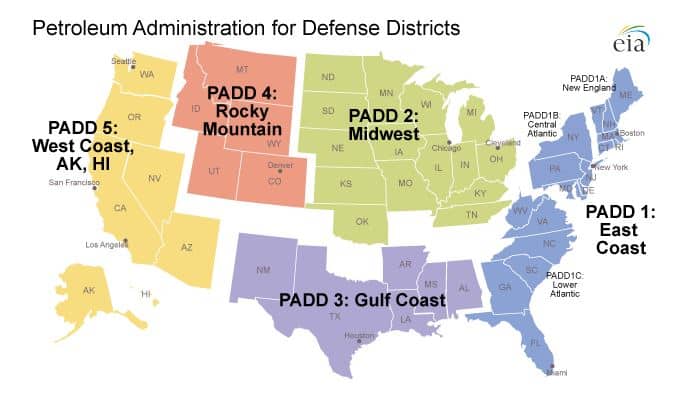
As the map above shows, there are five (5) different districts.
- PADD 1 covers the east coast from Maine to Florida. Due to the number of people and extent of this District, it is further broken down into three sub-districts.
- PADD 1A covers New England, including Connecticut, Maine, Massachusetts, New Hampshire, Rhode Island, and Vermont.
- PADD 1B covers the Central Atlantic region, including Delaware, the District of Columbia, Maryland, New Jersey, New York, and Pennsylvania.
- PADD 1C covers the Lower Atlantic, including Florida, Georgia, North Carolina, South Carolina, Virginia, and West Virginia.
- PADD 2 covers the Midwest. This district includes Indiana, Illinois, Iowa, Kansas, Kentucky, Minnesota, Nebraska, Michigan, North Dakota, Ohio, Oklahoma, South Dakota, Tennessee, and Wisconsin.
- PADD 3 covers the Gulf Coast, including Alabama, Arkansas, Louisiana, Mississippi, New Mexico, and Texas.
- PADD 4 covers the Rocky Mountain region, including Colorado, Idaho, Montana, Utah, and Wyoming.
- PADD 5 includes the West Coast. Alaska, Arizona, California, Hawaii, Nevada, Oregon, and Washington.
Two additional Districts (PADDs VI and VII) cover U.S. territories worldwide.
Since we no longer ration fuel AT ALL! You may be asking what is the point of the PADD now? It has become a data collection and analysis tool. Learning where the distribution and consumption of fuels are happening around the country is important. It is a great way for the industry to spot trends and patterns happening in each individual district instead of trying to look as the country as a whole.
Topics ranging from the impact of Gulf Coast hurricanes to the Keystone pipeline are easier to understand with this insightful data collection.
Fuel wholesalers, retailers, refineries, and producers must understand how fuel moves within the country. This knowledge helps to understand the problems with supply and demand that occur occasionally.
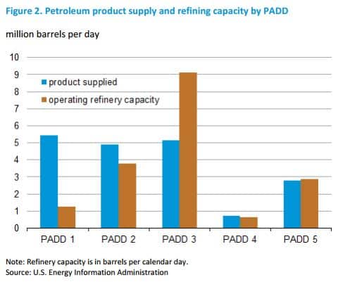
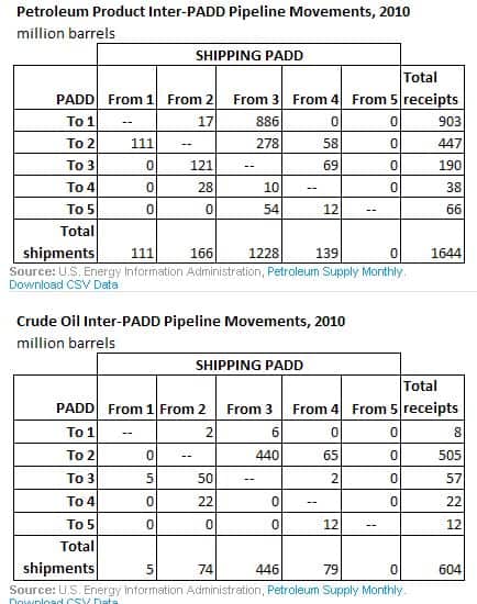
The graphs below are a bit out of date, but they give a perfect example of tracking data of petroleum products moving between the different districts.
So now we all know that if there is a civil war and we all have to deal with a post-apocalyptic situation like the movie Hunger Games, we already have our districts figured out. Big load off your mind, right?! I wonder who would be the capital district, PADD 3, maybe? We do have the biggest supply…..
Want to be able to power generators at your well site by utilizing the natural gas that you thought was just a by-product? Click the link below and learn how Croft Production Systems can clean, dehydrate or condition your natural gas to power your site and save you money.
Resources:
http://www.eia.gov/analysis/transportationfuels/padd5/pdf/transportation_fuels.pdf